Published in Windlesora 31 (2015)
© WLHG
Visitors to Windsor who arrive from the west, either by road or rail, cannot fail to notice Ward Royal. This modern block of flats, opened by the Queen on 23rd June 1969, won awards for its innovative architecture.
Older Windsorians remember a very different townscape consisting of Victorian houses and shops. With a growing interest in family history, people who are trying to trace their ancestors may find themselves puzzling over addresses such as 43 Victoria Cottages, Clewer or 5 Denmark Street, Clewer. These two addresses actually refer to the same property, and while it may be tempting to think that it was situated in Clewer village, it was actually part of the community which later made way for Ward Royal, because the parish of Clewer included all property to the west of Peascod Street.
Until the early nineteenth century, the whole area between Peascod Street and Clewer church was undeveloped, with the open meadows being susceptible to flooding from the river. The only road was Clewer Lane (later Oxford Road) which was frequently impassable. In the 1830s, the Bedborough estate including Clarence Crescent, Trinity Place and Holy Trinity Church was built, with New Road (later Clarence Road) forming a new westerly route above the flood line.
Then in 1849, the Great Western Railway line cut a swathe across the meadows into the heart of the town, elevated on its now-familiar viaduct. By the end of the nineteenth century, terraces of houses had been built on every available plot of land to the west and south of Peascod Street. Most were known by their terrace name, many of which can still be seen as plaques on Victorian buildings, but it was only in the 1880s that more formal numbering systems were adopted.
Victoria Cottages consisted of 106 houses built between Arthur Road to the north, Clewer Lane to the south, Alma Road to the west and Peascod Street to the east. They were renamed Grosvenor Place, Denmark Street and Edward Square, but for many years were known by both names. The map shows them as they were in 1956, about ten years before they were demolished.
The detective work to discover which of the Victoria Cottages related to which later address involves cross-referencing Trade Directories, Ordnance Survey maps and censuses, but the following is as accurate as possible:
| Victoria Cottages | Afterwards |
|---|---|
| 1-21 | became 1-21 Goswell Road |
| 22-23 | remained 22-23 Victoria Cottages (on the north side of Grosvenor Place) |
| 24-41 | became 32-2 (even numbers) Denmark Street (west side) |
| 42-54 | became 1-31 (odd numbers) Denmark Street (east side) |
| 55-67 | became 24-2 (evens) Edward Square (west) |
| 68-80 | became 1-27 (odds) Edward Square (east) |
| 81-100 | became 1-41 (odds) Grosvenor Place (south) |
| 101-106 | were in Goswell Road, but still called Victoria Cottages. |

An additional trap for the unwary researcher is that Denmark Street, Edward Square and Grosvenor Place had no number 13, so the numbering jumped from 11 to 15 in each case.
The demolition of Victoria Cottages began in 1967, along with houses on the south side of Arthur Road, Oxford Road shops and pubs and South Place which was along the boundary wall of Clarence Crescent. For a short period, the cleared area was used as a car park, allowing a clear view from Alma Road up to the Castle, Central Railway station and town centre.

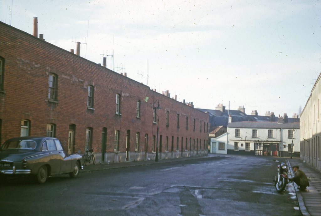
The photographs of Edward Square (courtesy of the Royal Windsor Website, copyright John Handcock) show the even numbers on the right and odd numbers on the left. The motorbike is outside number 6 and the pub in the background is the Victoria Arms in Grosvenor Place.
